
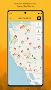
Real-time wildfire alerts and maps in the Western US


Watch Duty, a 501(c)(3) nonprofit, alerts you of nearby wildfires and firefighting efforts in real-time when every second counts.
Our FREE service is powered by real people – active and retired firefighters, dispatchers, and first responders – who diligently monitor radio scanners and collaborate around the clock to bring you up-to-the-minute life saving information.
We are the only fire tracking, mapping, and monitoring app that is powered by real people which means you get real-time information vetted by trained professionals, not robots.
Features include:
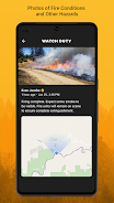
- Real-time notifications about the status and conditions on the ground as they change.
- Track active fire perimeters and progress using satellite imagery and other official sources.
- Air quality & wind direction
- Evacuation orders & shelters
- Share photos of fire starts and other hazardous conditions for first responders and the world to see
Our FREE service is powered by real people – active and retired firefighters, dispatchers, and first responders – who diligently monitor radio scanners and collaborate around the clock to bring you up-to-the-minute life saving information.
We are the only fire tracking, mapping, and monitoring app that is powered by real people which means you get real-time information vetted by trained professionals, not robots.
Features include:
- Real-time notifications about the status and conditions on the ground as they change.
- Track active fire perimeters and progress using satellite imagery and other official sources.
- Air quality & wind direction
- Evacuation orders & shelters
- Share photos of fire starts and other hazardous conditions for first responders and the world to see


